Monday, June 17, 2013

Kearney, NE to Ames, IA Day #7

Monday, June 17, 2013.


Today we left Kearney, NE for points east. The time zone changed to Central time about 100 miles west of where we stayed and caused confusion in the morning. We first ate a quick breakfast at Subway without great coffee. We then headed to the Kearney visitor center to pick up a booklet on the Lincoln Highway through Nebraska. I asked the young woman at the center what the sirens were that we heard the following evening. She informed me that that was a tornado warning. Interesting that no one at the motel expressed any concern or informed us of the issue.

We then went to a souvenier shop to pick up Lincoln Highway T-shirts. I asked the owner, a Nebraska native, what we should do if we encounter a tornado on the Nebraska flat lands. He said to drive the other way. Hummm...local knowledge was of little help to us.

Heading east out of Kearney, we first encountered the Morris Cookbook publishing company on Route 30. We stopped to see what they did and they had a package to assit you in publishing your own cookbook. Earline has been thinking of this for a long time and this might finally spur her onward. They had hundreds of cookbooks that are self-published for charitable events at reasonable costs.

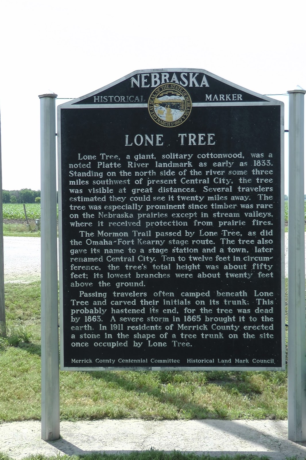
During our eastward travel, we stopped at historical markers along the roadway. One of these markers described a landmark called Lone Tree. This was a giant cottonwood tree, 20 feet in diameter that could be seen for 20 miles and was used by the early travelers of the California Trail or the Mormon Trail and others to guide their journey. Unfortunately, the tree blew down during a storm in 1865. The site was supposed to be marked by a concrete marker but we could not locate the marker.
Another interesting marker in Columbus, Nebraska, describes the North Brothers who were Indian fighters. You can read about them here.


We crossed the border to Iowa at the Missouri River. You couldn't help but wonder how the early pioneers got across that river with their wagons and horses. Here is some information on how the Mormons got to the crossing point. Times were tough in those days. When the Union Pacific Railroad got established, the trails became obsolete.


Upon crossing the Missouri River, we came into Iowa and the visitor center is about 14 miles to the east. We stopped there and watched a movie on the Loess Hills of Iowa and a short film on the history of the Lincoln Highway. Both were very informative.


These hills were forms from the glaciers grinding rocks onto dust that then piled up as the wind blew. They are only found in this narrow band of Iowa and in China.

The visitor center had an original Lincoln Highway marker and an example of the Lincoln Highway going from dirt to gravel to cement.

Dirt to Gravel to Cement

Loess Hills in Iowa

Historical Museum at Welcome Center

Original Lincoln Highway Marker


Passing through Iowa brings a different perspective from the flat lands of Nebraska. There are still many cornfields but the land begins to roll gently and trees are more abundant. Several towns are larger than many with only 300 to 400 at the site of grain silos next to the railroad. 

Eventually, we came to Ames, IA that has the University of Iowa in its midst. We decided we travelled far enough and stopped for the night at the Economy 8 motel for $60 for a king suite after senior discount. Dinner was taken at a local brewery called Olde Main Brewing Company and Restaurant. The beer and food was only mediocre.


Following dinner and failing to find any tango on a Monday night, we returned to our motel to get some rest.


Sunday, June 16, 2013

Day #6 Laramie, WY to Kearney, NE

6/16/13 Sunday - Day #6  Laramie, WY to Kearney, Nebraska


Today was a very pleasant drive from Laramie, Wyoming to Kearney, Nebraska. We started out on Interstate 80 for a short distance but soon we exited to follow Route 30, the site of the Lincoln Highway.

As we left Laramie and headed east on Interstate 80, at about 11 miles east at exit 323, you come to a rest stop that is located at the highest point on the Interstate 80 system. It is about 8300 feet high and contains a statue of Abraham Lincoln and a monument to Henry Bourne Joy, the president of Packard Motors and a proponent for the Lincoln Highway. 


He often camped at the highest point. The real highest point is across the road along Route 30 and it is even higher. We took a picture of us on the original Lincoln Highway before following Route 30 for the rest of the day.


Lincoln Head Monument
Lee & Earline on the original Lincoln Highway at the highest point, 8800 feet elevation.

Following Route 30, we came into Cheyenne, WY, the capitol city of Wyoming. The downtown is quaint and it is interesting to take a quick walk around several blocks to get a flavor of the old part of town. The visitor's center is located in the Cheyenne Depot Plaza, a site of the old trolly cars. Unfortunately it was closed on Sunday.


Downtown Cheyenne, WY


A statue entitled "A New Beginning"


Lincoln Highway marker in downtown Cheyenne, WY


Capitol Building - Cheyenne, WY


From Cheyenne, we went through many small towns and noted a variety of historical sites. One of the sites showed an irrigation flume in Kimball, WY. This flume was used to bring water to the area for farming.


We stopped for lunch at Grandma Jo's in Sidney, NE. The food was meat and potatoes and Earline was forced into a grilled cheese sandwich with a salad bar of iceberg lettuce. She wanted whole wheat bread but they substituted white. I told her to forget about it! She asked if they had WiFi and I laughed when they looked strangely at her. :)


Typical sights from Route 30 of a multitude of corn silos!

I have no idea what the Boxing Highway means.


Road hazards of farm machinery.


Old Vintage Texaco Station


Lee & Earline on an old Lincoln Highway bridge to nowhere. Earline was screaming there were snakes in the grass as I made her go to the bridge for a picture. :)

We arrived in Kearney, NE at about 4:30 pm and checked into the Western Inn South, a budget motel that is clean and has two Queen beds for $34.50 for the first person, $8 for the second and a small amount of tax. I am glad we don't have our pets because the charge $15/pet. That could get pricey with three dogs. :)

Now we will decide on dinner. The brewpubs are closed on Sunday and this disappoints Earline. :)


Saturday, June 15, 2013

Evanston, WY to Laramie, WY - Day #5

Saturday, June 15, 2013 - Day #5

We left Evanston, WY at about 7:30 in the morning after being unable to find a decent cup of coffee. The liquid from the motel and from the gas station were both like lukewarm dishwater. Still, it served the purpose of getting us on the road after the long drive yesterday.

We headed towards Laramie, Wyoming with the intent of exploring the little towns off Interstate 80 that closely followed the Lincoln Highway. Only by leaving the highway on Route 30 through the towns could we be certain we were actually on the old road.

About 70 miles to the east of Evanston, you come to "Little America", a tourist stop built by the Sinclair Oil magnate. It has restrooms, hot showers for truckers and a gift shop for tourists. They also provide rooms if needed and hot meals. Other than this, there is nothing there.

Cheesy dinosaur at Little America


Lots of flat land with nothing on it.


The next town of interest is Green River, WY. We stopped at the tourist center and spoke with the docent. He educated us as to the area and the industry of mining of Sodium Sesquicarbonate. This is the mineral from which baking soda is made and I never knew it was mined from about a mile underground by the Tata Corporation.

Here you can read about the making of sodium bicarbonate and sodium carbonate:

Making Baking Soda


Green River, WY


Mushroom Rock at Green River, WY

Same rock with people on it in the early 1900's

As we exited Green River via Route 30, we found documentation of the Lincoln Highway on an old garage.


After traveling through a lot of flat land with sparse cows and occasional oil wells, we came to Rock Springs, WY. If you exit Interstate 80 and follow Business 80/Route 30, you can document the Lincoln Highway with a marker just across from the Budget Host Motel that might be original during the LH time.


Rock Springs was a stop for the Union Pacific Railroad and because coal was discovered under the town, the coal was used for the steam engines. This created a large town with a diverse population of miners from many countries. The town had the first neon sign in the Rocky Mountains and this has been restored and placed at the entrance to a walking tunnel under the rail tacks that leads to the old, historic section of the town.

First Neon Sign in the Rocky Mountains

Old Historic Rock Springs - Not much there

Gaudy dresses for sale

Tunnel under the rail tracks

History of Rock Springs

Very first electric mine engine

As we exited Rock Springs on Route 30, we looked for more Lincoln Highway signs but could only find a Happy Buddah that Earline wanted to capture in picture. :)

At 177 miles east of Evanston, WY. we crossed the Continental Divide. You will recall that this is the point where water shed either flows west to rivers that go to the Pacific Ocean or to the Great Basin or east to the Mississippi River.

We arrived in Laramie, WY at about 3:30 pm and toured the small town briefly and then check into The Best Value Inn at 523 S. Adams St. Room cost was $64.90 including tax and after a brief rest, we set out to explore the town before stores close. Earline was scanning for microbreweries and we found the only one, called The Altitude Chophouse and Brewery. Before imbibing, we walked the town and Earline found a quilt shop to purchase threads and a custom yarn shop with handmade and hand dyed wools. She purchased a skein for $56...ouch! Still the wool was unique and since the owner had lived in Silicone Valley in the past and had worked for Stanford University, she got special dispensation for a sale. We chatted about the weather in the winter and she told me they get about 3 months of nice weather and the winters are VERY severe with high, bone-chilling winds.

After an adequate dinner of initially slimy shimp salad and pink beef coupled with great dark beer (Stoudt and Porter) we drove by Wyoming University and briefly checked out the crown jewel of Laramie, the Iverson Mansion before returning to the motel.


Distance traveled today = 308 miles. Tomorrow we move on to Cheyenne, WY and points east.